| Provisional Timetable for WADAC Track2Track Relay. Last published: 07-September-2012 | |||||
| Stage Summaries: Click Here | |||||
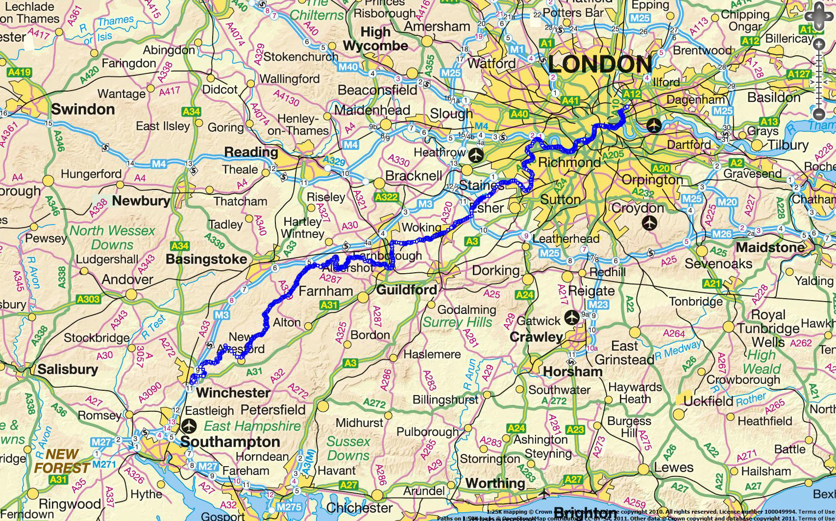
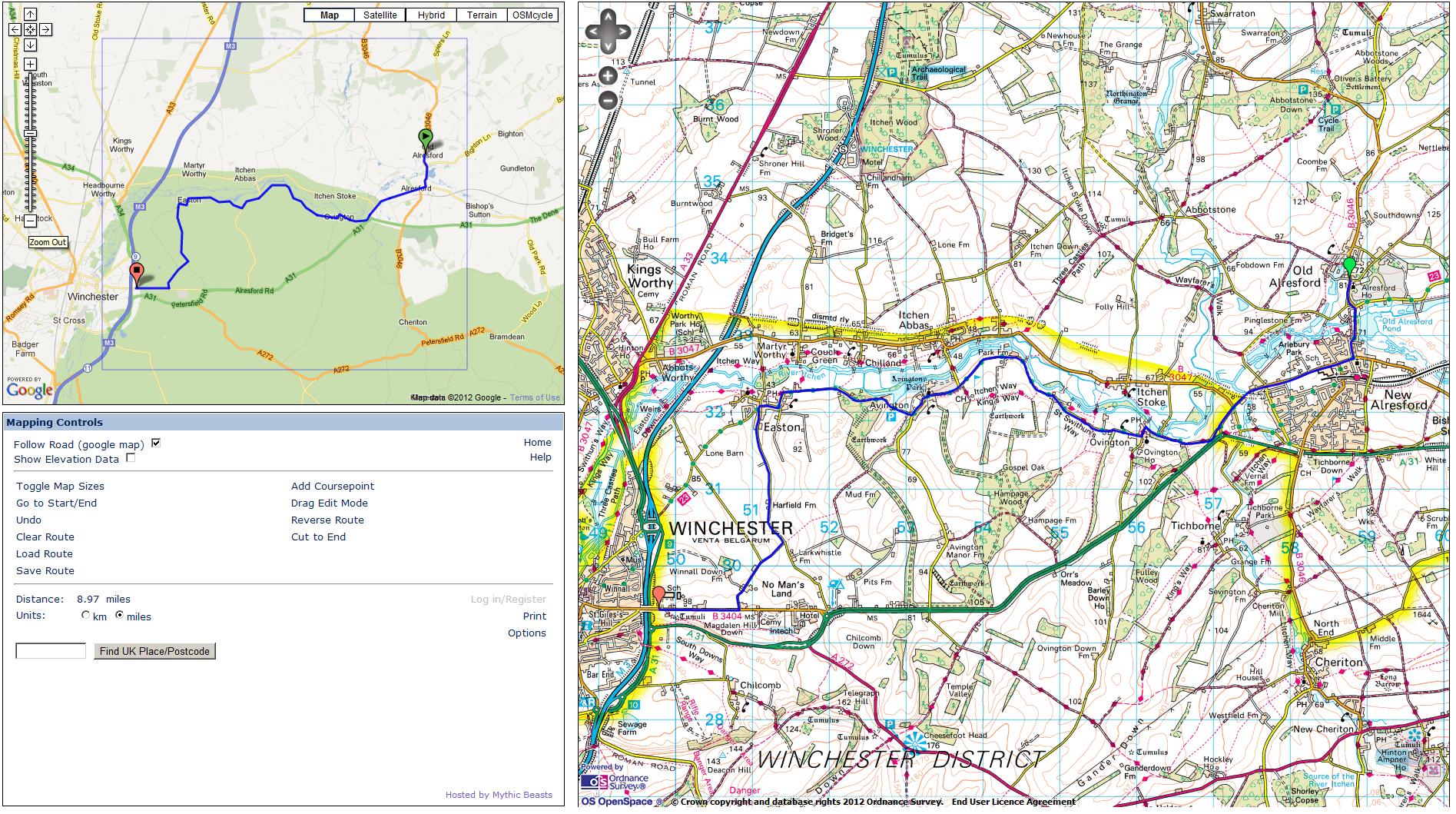
| Overview Map: Click Here | Mean pace = 9.50 min/mi | ||||
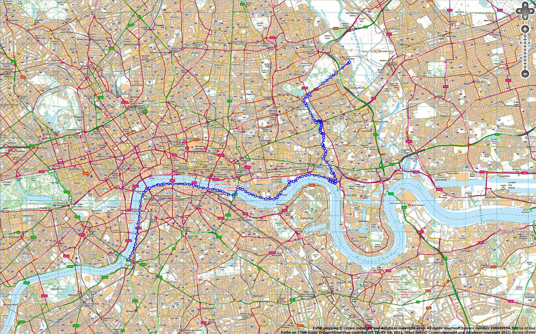
| Stage 1: | Hackney Wick to Vauxhall Bridge (via canals then Thames Path) | ||||
| Stage Mileage (mi): | 9.2 | Stage route map (overview) | |||
| Cumulative Mileage (mi): | 9.2 | ||||
| START Time: | 1:00 AM | ||||
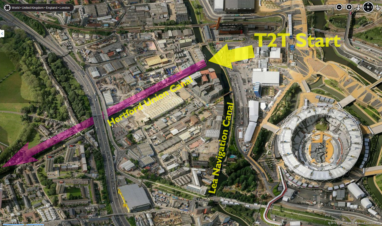
| START Location: | Hackney Wick (with view of Olympic Stadium) | Satellite image of EXACT START location | |||
| START Post Code (approximately): | E9 5EN | ||||
| START OS co-ordinates: | TQ373844 | Streemap of EXACT START location | |||
| FINISH Time: | 2:27 AM | ||||
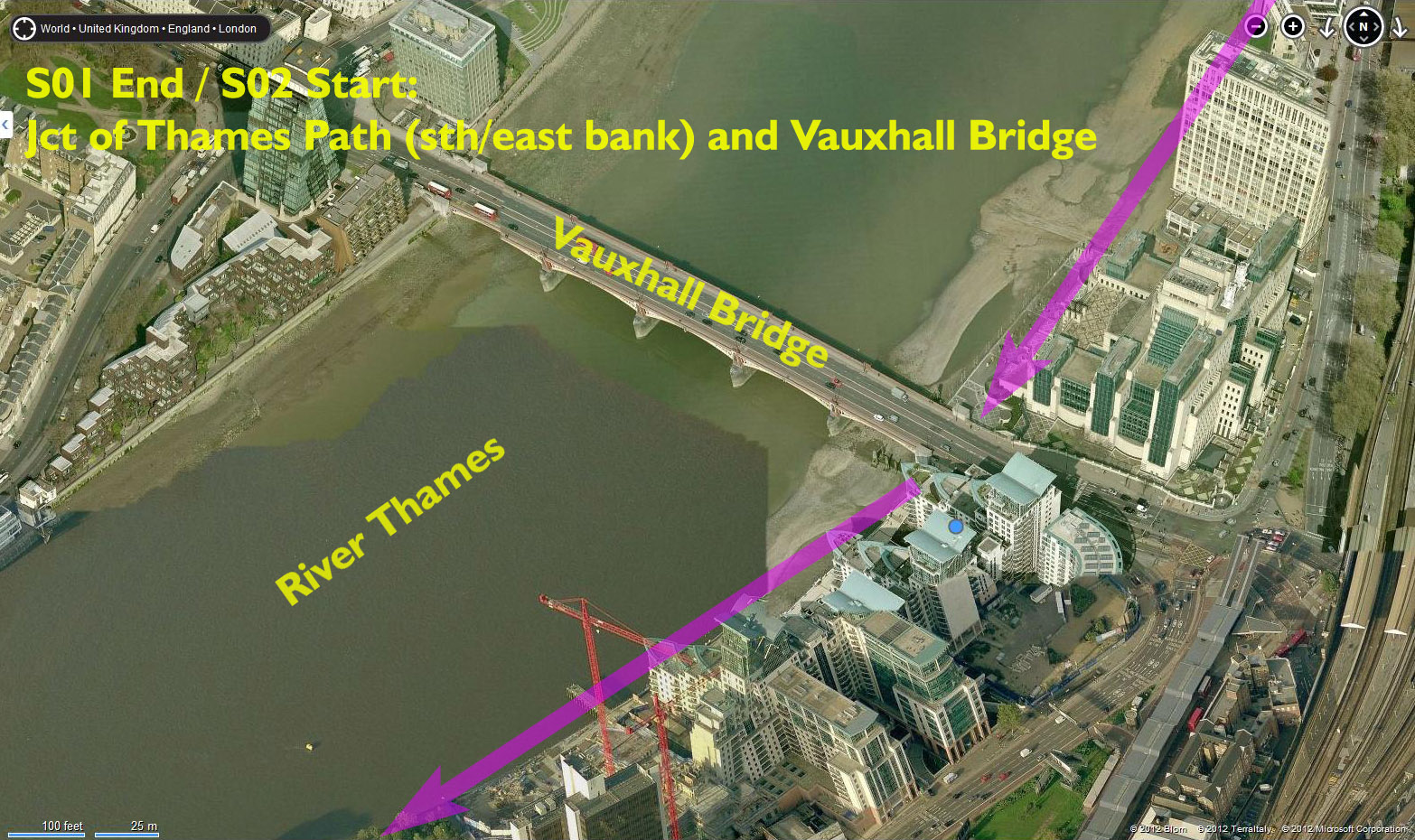
| FINISH Location: | Vauxhall Bridge (A202), Vauxhall | Satellite image of EXACT FINISH location | |||
| FINISH Post Code (approximately): | SW8 2LP | ||||
| FINISH OS co-ordinates: | TQ303781 | Streemap of EXACT FINISH location | |||
| 1. Start at junction of River Lea Navigation and Hertford Union
Canal (NW corner of junction). 2. Start heading west on north bank of Hertford Union Canal, between canal (on left) and Victoria Park (on right). 3. After 1.2mi turn LEFT to follow Regents Canal on east bank (canal is on the right). 4. After 1.5mi arrive at Limehouse Basin. 5. Turn left and follow basin perimeter for 0.3mi to meet Narrow Street. Turn right (west) onto Thames Path. ** 6. Follow Thames Path westwards on north bank. |
|||||
| Garmin files (right-click to download): | s01.tcx | s01.gpx | |||
| Detailed map download: | Detailed map (zoomable Google map overlay) | ||||
| Designated runner(s): | Ian J Berry | ||||
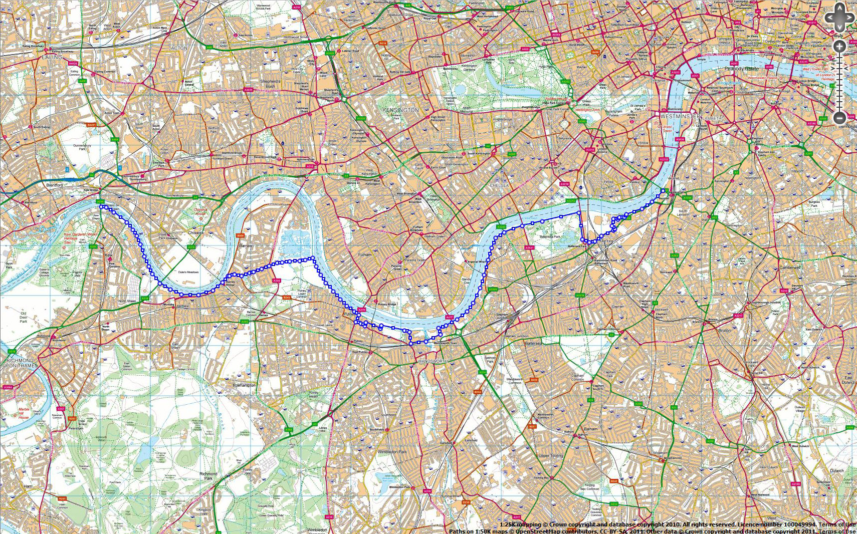
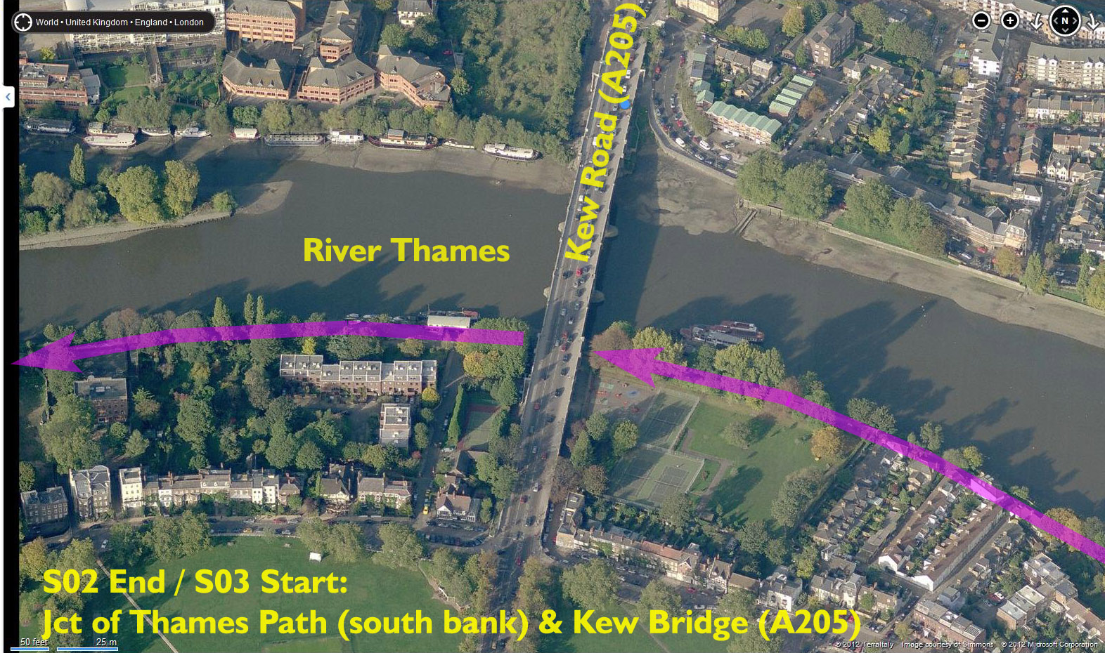
| Stage 2: | Vauxhall Bridge to Kew Bridge (via Thames Path with shortcut at Barnes) | ||||
| Stage Mileage (mi): | 9.8 | Stage route map (overview) | |||
| Cumulative Mileage (mi): | 19 | ||||
| START Time: | 2:27 AM | ||||
| START Location: | Vauxhall Bridge (A202), Vauxhall | Satellite image of EXACT START location | |||
| START Post Code (approximately): | SW8 2LP | ||||
| START OS co-ordinates: | TQ303781 | Streemap of EXACT START location | |||
| FINISH Time: | 4:00 AM | ||||
| FINISH Location: | Kew Bridge / Kew Road (A205), Brentford | Satellite image of EXACT FINISH location | |||
| FINISH Post Code (approximately): | W4 3NG | ||||
| FINISH OS co-ordinates: | TQ190778 | Streemap of EXACT FINISH location | |||
| 1. Start at Vauxhall
Bridge. 2. Leave on the Thames Path on the SOUTH bank of the Thames in a westerly direction. 3. Follow Thames Path (all on SOUTH bank). 4. Please follow GPX flle to take short-cut at Barnes. 5. Rejoin Thames Path (SOUTH bank) to finish UNDER Kew Bridge. |
|||||
| Garmin files (right-click to download): | s02.tcx | s02.gpx | |||
| Detailed map download: | Detailed map (zoomable Google map overlay) | ||||
| Designated runner(s): | Richard Nichols, Ian J Berry | ||||
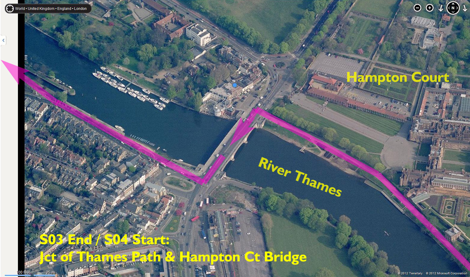
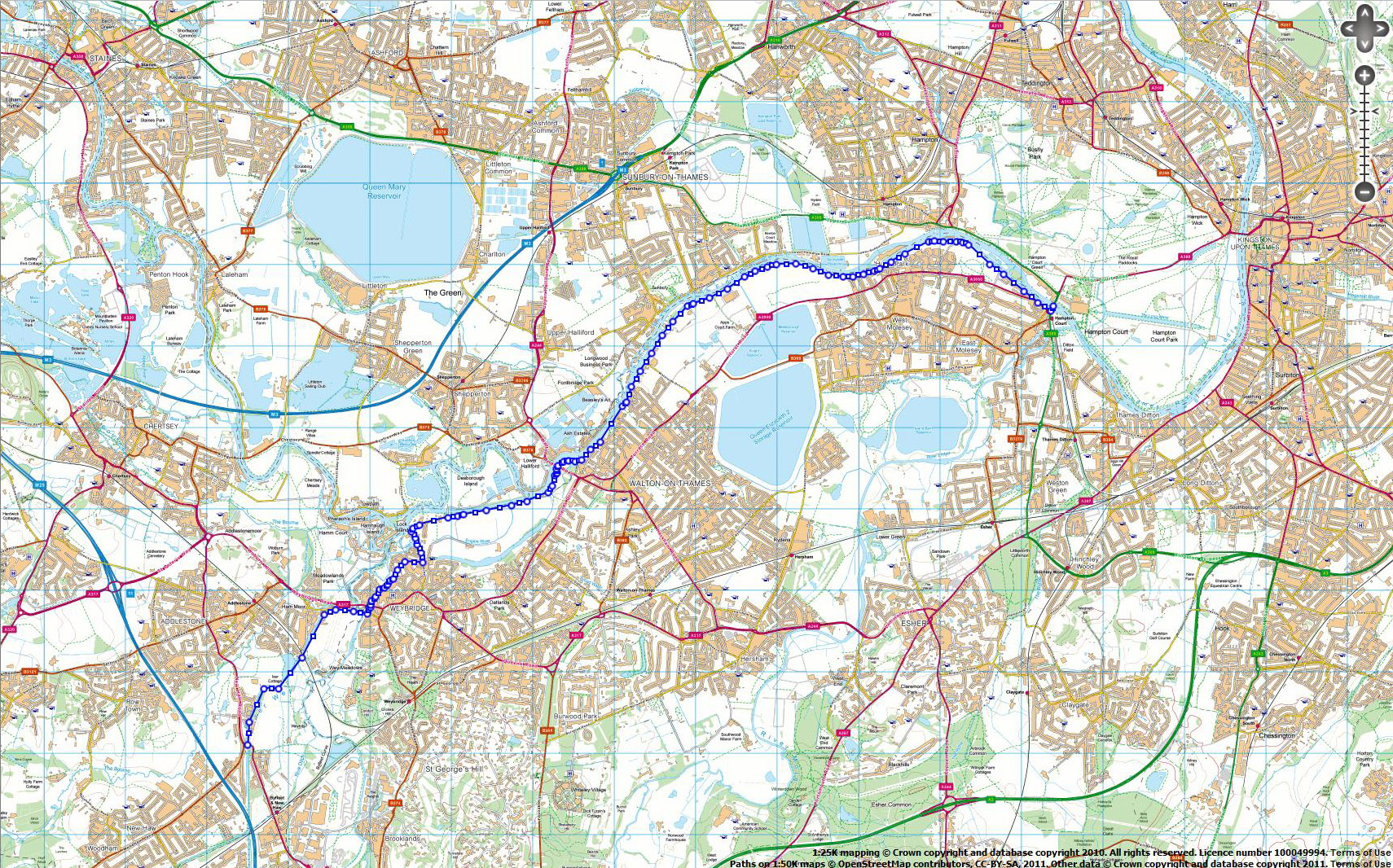
| Stage 3: | Kew Bridge to Hampton Court Bridge (via Thames Path) | ||||
| Stage Mileage (mi): | 10.4 | Stage route map (overview) | |||
| Cumulative Mileage (mi): | 29.4 | ||||
| START Time: | 4:00 AM | ||||
| START Location: | Kew Bridge / Kew Road (A205), Brentford | Satellite image of EXACT START location | |||
| START Post Code (approximately): | W4 3NG | ||||
| START OS co-ordinates: | TQ190778 | Streemap of EXACT START location | |||
| FINISH Time: | 5:39 AM | ||||
| FINISH Location: | Hampton Court Bridge (A309) | Satellite image of EXACT FINISH location | |||
| FINISH Post Code (approximately): | KT8 9BN | ||||
| FINISH OS co-ordinates: | TQ154685 | Streemap of EXACT FINISH location | |||
| 1. Start UNDER Kew Bridge. The Thames Path crosses BENEATH this
bridge on the south bank. 2. Leave bridge in a westerly direction, on SOUTH bank of Thames. 3. Cross Thames at Kingston Bridge to NORTH bank of Thames (adjacent to Hampton Court Pk). 4. Follow Thames Path to finish. |
|||||
| Garmin route files: | s03.tcx | s03.gpx | |||
| Detailed map download: | Detailed map (zoomable Google map overlay) | ||||
| Designated runner(s): | Karen Hazlitt, Michaela McCallum, Mike Davies | ||||
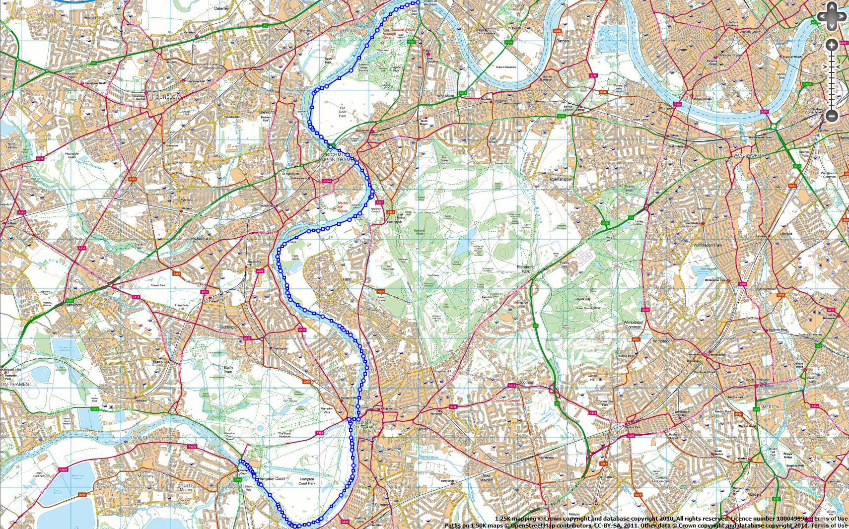
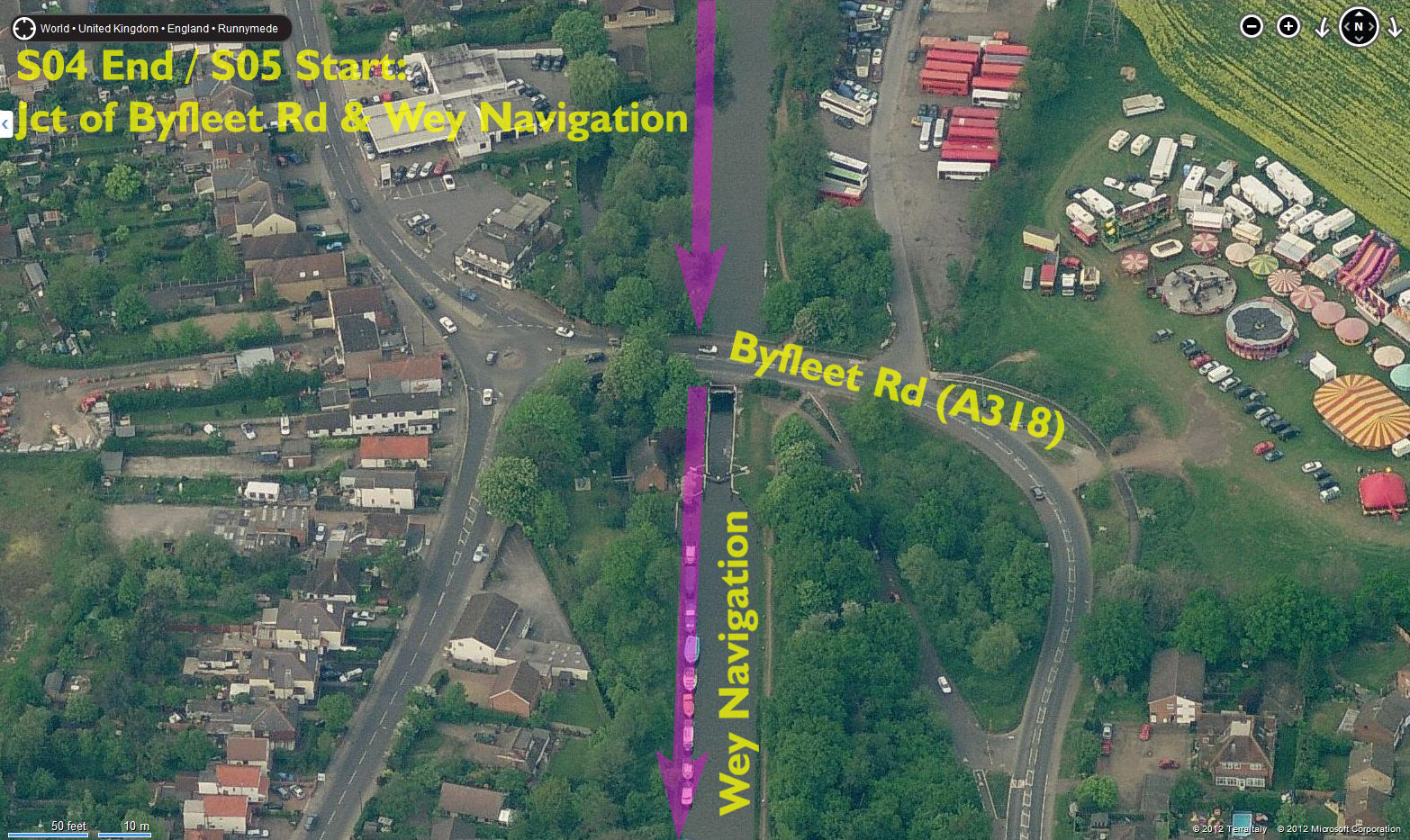
| Stage 4: | Hampton Court Bridge to West Byfleet (via Thames Path, streets, then Wey Navigation) | ||||
| Stage Mileage (mi): | 8.7 | Stage route map (overview) | |||
| Cumulative Mileage (mi): | 38.1 | ||||
| START Time: | 5:39 AM | ||||
| START Location: | Hampton Court Bridge (A309) | Satellite image of EXACT START location | |||
| START Post Code (approximately): | KT8 9BN | ||||
| START OS co-ordinates: | TQ154685 | Streemap of EXACT START location | |||
| FINISH Time: | 7:01 AM | ||||
| FINISH Location: | Byfleet Rd (A318), West Byfleet | Satellite image of EXACT FINISH location | |||
| FINISH Post Code (approximately): | KT15 3NA | ||||
| FINISH OS co-ordinates: | TQ055631 | Streemap of EXACT FINISH location | |||
| 1. Start on Hampton Court Bridge. The Thames Path crosses this
bridge to move from one bank to the other. 2. Leave bridge on SOUTH bank of Thames. Follow Thames Path in a westerly direction for 3.8mi. 3. At Walton Bridge Road, do NOT follow TP across river (at bridge works) but continue ahead on Walton Ln. 4. Follow Walton Ln for a further 1.3mi. 5. Follow GPX route for 1.2mi on road, to meet the River Wey Navigation off Addlestone Rd. 6. Follow River Wey Navigation in southerly direction to finish. |
|||||
| Garmin files (right-click to download): | s04.tcx | s04.gpx | |||
| Detailed map download: | Detailed map (zoomable Google map overlay) | NEW!! DETAILED TURN-BY-TURN DIRECTIONS (PDF file) | |||
| Designated runner(s): | Jackie Ducker, Adrian Field, Susan Bryan | ||||
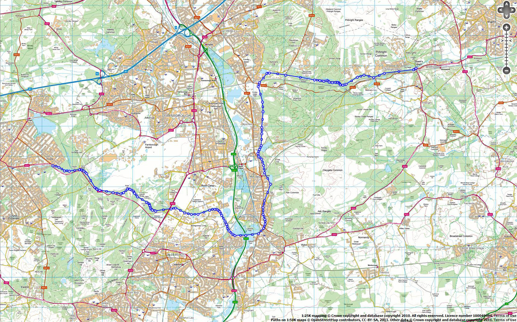
| Stage 5: | West Byfleet to Brookwood (via River Wey Navigation & Basingstoke Canal) | ||||
| Stage Mileage (mi): | 9.0 | Stage route map (overview) | |||
| Cumulative Mileage (mi): | 47.1 | ||||
| START Time: | 7:01 AM | ||||
| START Location: | Byfleet Rd (A318), West Byfleet | Satellite image of EXACT START location | |||
| START Post Code (approximately): | KT15 3NA | ||||
| START OS co-ordinates: | TQ055631 | Streemap of EXACT START location | |||
| FINISH Time: | 8:27 AM | ||||
| FINISH Location: | Brunswick Rd, Brookwood | Satellite image of EXACT FINISH location | |||
| FINISH Post Code (approximately): | GU24 0AD | ||||
| FINISH OS co-ordinates: | SU947583 | Streemap of EXACT FINISH location | |||
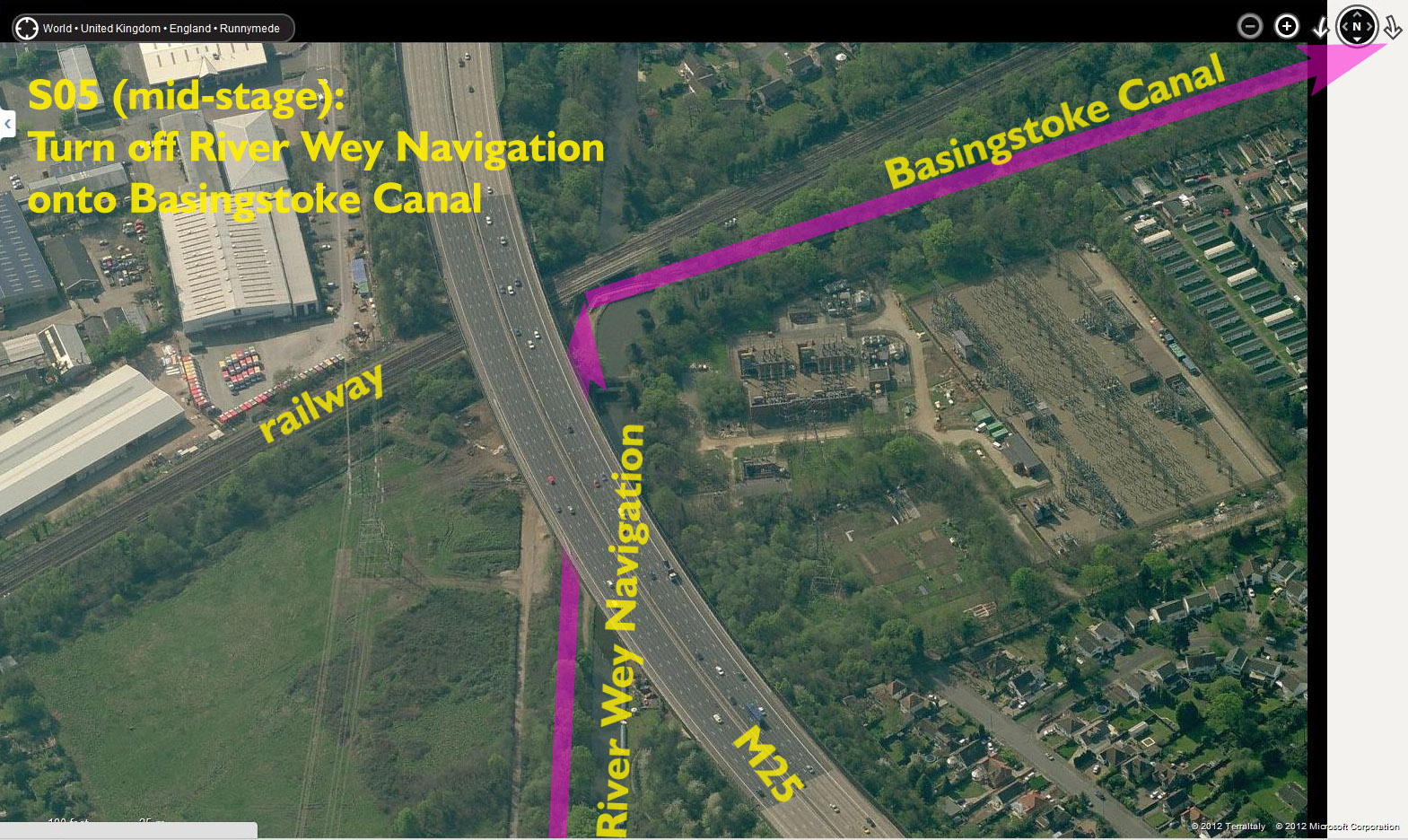
| 1. Start on Byfleet Rd, 1/4mi north of The White Hart PB. Start
where Wey Navigation crosses Byfleet Rd. 2. Follow River Wey Navigation southwards for 0.67mi to meet Basingstoke Canal. 3. Use footbridge to turn right and cross River Wey Navigation. ** 4. Follow Basingstoke Canal tow path west to finish. |
|||||
| Garmin route files: | s05.tcx | s05.gpx | |||
| Detailed map download: | Detailed map (zoomable Google map overlay) | ** Satellite image of turn onto Basingstoke Canal | |||
| Designated runner(s): | Andy Parkinson, Steve Oliver, Carrie Oliver, Sarah Aldridge, Steve Goodwin | ||||
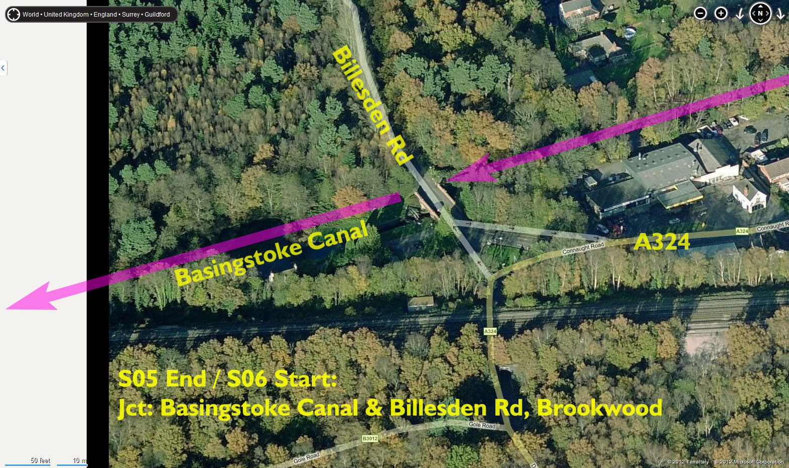
| Stage 6: | Brookwood to Fleet (via Basingstoke Canal) | ||||
| Stage Mileage (mi): | 11.8 | Stage route map (overview) | |||
| Cumulative Mileage (mi): | 58.9 | ||||
| START Time: | 8:27 AM | ||||
| START Location: | Brunswick Rd, Brookwood | Satellite image of EXACT START location | |||
| START Post Code (approximately): | GU24 0AD | ||||
| START OS co-ordinates: | SU947583 | Streemap of EXACT START location | |||
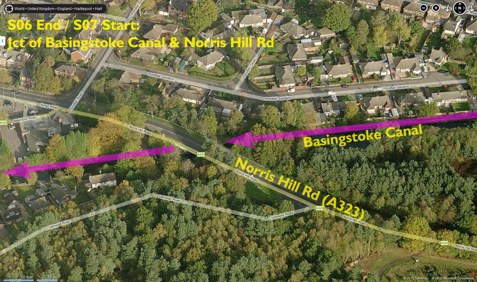
| FINISH Time: | 10:19 AM | ||||
| FINISH Location: | Norris Hill Rd (A323), Fleet, Hants | Satellite image of EXACT FINISH location | |||
| FINISH Post Code (approximately): | GU52 7LZ | ||||
| FINISH OS co-ordinates: | SU823537 | Streemap of EXACT FINISH location | |||
| 1. Start on canal tow path where Billesden Rd crosses
Basingstoke Canal, 0.5mi west of Brookwood railway stn. 2. Follow canal westerly to finish point, on canal. |
|||||
| Garmin route files: | GPX / CRS (to be added) | ||||
| Detailed map download: | (to be added) | ||||
| Designated runner(s): | Emma Patel, Stephen Lowy, Joy Radford, Rachel Byers | ||||
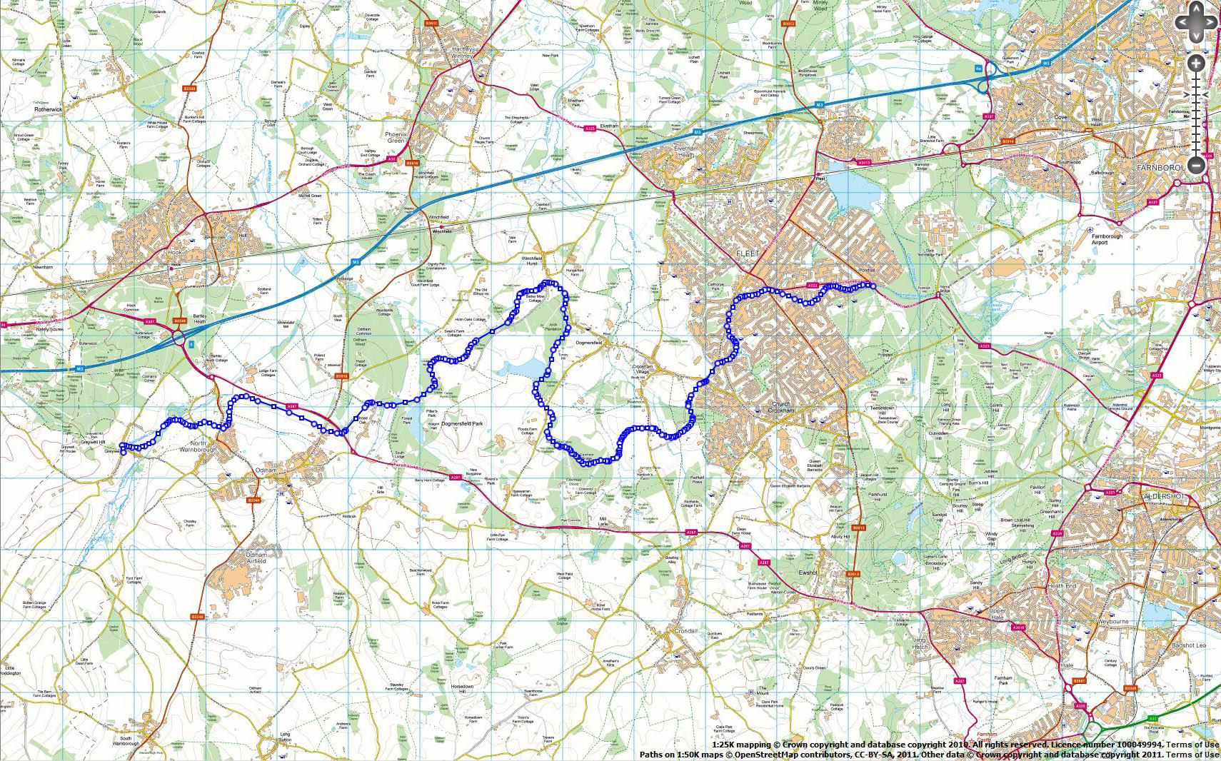
| Stage 7: | Fleet to Greywell (via Basingstoke Canal) | ||||
| Stage Mileage (mi): | 10.7 | Stage route map (overview) | |||
| Cumulative Mileage (mi): | 69.6 | ||||
| START Time: | 10:19 AM | ||||
| START Location: | Norris Hill Rd (A323), Fleet, Hants | Satellite image of EXACT START location | |||
| START Post Code (approximately): | GU52 7LZ | ||||
| START OS co-ordinates: | SU823537 | Streemap of EXACT START location | |||
| FINISH Time: | 12:01 PM | ||||
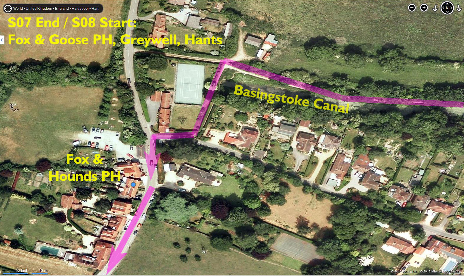
| FINISH Location: | Fox and Goose PH, Greywell, Hants | Satellite image of EXACT FINISH location | |||
| FINISH Post Code (approximately): | RG29 1BY | ||||
| FINISH OS co-ordinates: | SU718514 | Streemap of EXACT FINISH location | |||
| 1. Follow Basingstoke Canal to the (closed) Greywell
tunnel. 2. Cross over canal at tunnel and emerge (1/4mi) onto tarmac road with Fox and Goose PH immediately ahead. |
|||||
| Garmin route files: | GPX / CRS (to be added) | ||||
| Detailed map download: | (to be added) | ||||
| Designated runner(s): | Nathan Risbey, Emma Patel | ||||
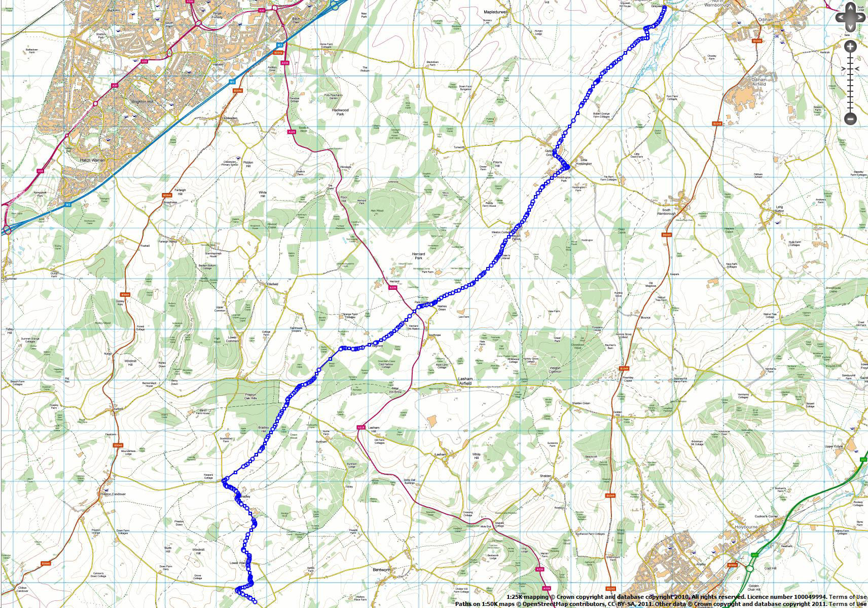
| Stage 8: | Greywell to Upper Wield (via country lanes) | ||||
| Stage Mileage (mi): | 10.6 | Stage route map (overview) | |||
| Cumulative Mileage (mi): | 80.2 | ||||
| START Time: | 12:01 PM | ||||
| START Location: | Fox and Goose PH, Greywell, Hants | Satellite image of EXACT START location | |||
| START Post Code (approximately): | RG29 1BY | ||||
| START OS co-ordinates: | SU718514 | Streemap of EXACT START location | |||
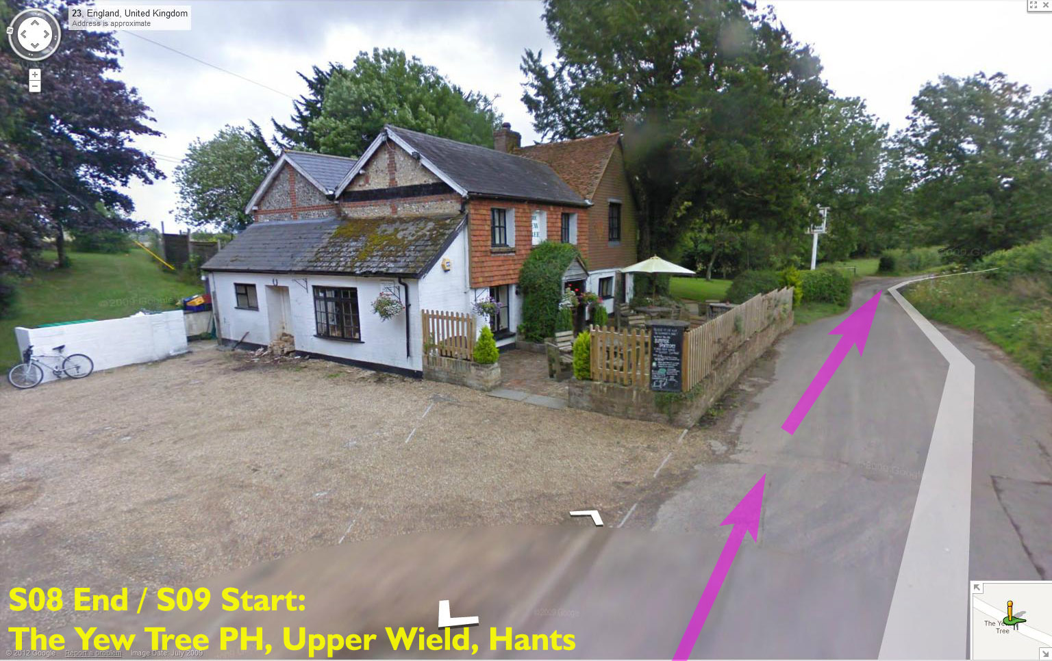
| FINISH Time: | 1:41 PM | ||||
| FINISH Location: | The Yew Tree PH, Lower Wield, Hants | Satellite image of EXACT FINISH location | |||
| FINISH Post Code (approximately): | SO24 9RX | ||||
| FINISH OS co-ordinates: | SU636398 | Streemap of EXACT FINISH location | |||
| 1. Leave pub heading south-west and follow roads on GPX route file and/or route map. | |||||
| Garmin files (right-click to download): | s08.tcx | s08.gpx | |||
| Detailed map download: | Detailed map (zoomable Google map overlay) | ||||
| Designated runner(s): | Paul Brittenden, Kath Bailey | ||||
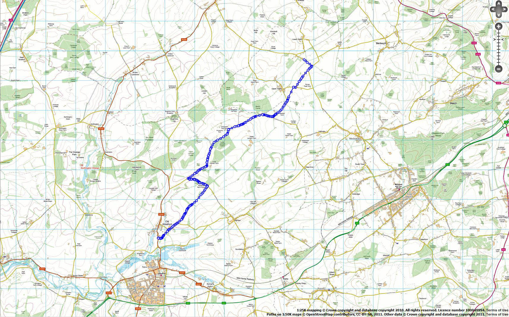
| Stage 9: | Upper Wield to Old Alresford (via country lanes) | ||||
| Stage Mileage (mi): | 6.0 | Stage route map (overview) | |||
| Cumulative Mileage (mi): | 86.2 | ||||
| START Time: | 1:41 PM | ||||
| START Location: | The Yew Tree PH, Lower Wield, Hants | Satellite image of EXACT START location | |||
| START Post Code (approximately): | SO24 9RX | ||||
| START OS co-ordinates: | SU636398 | Streemap of EXACT START location | |||
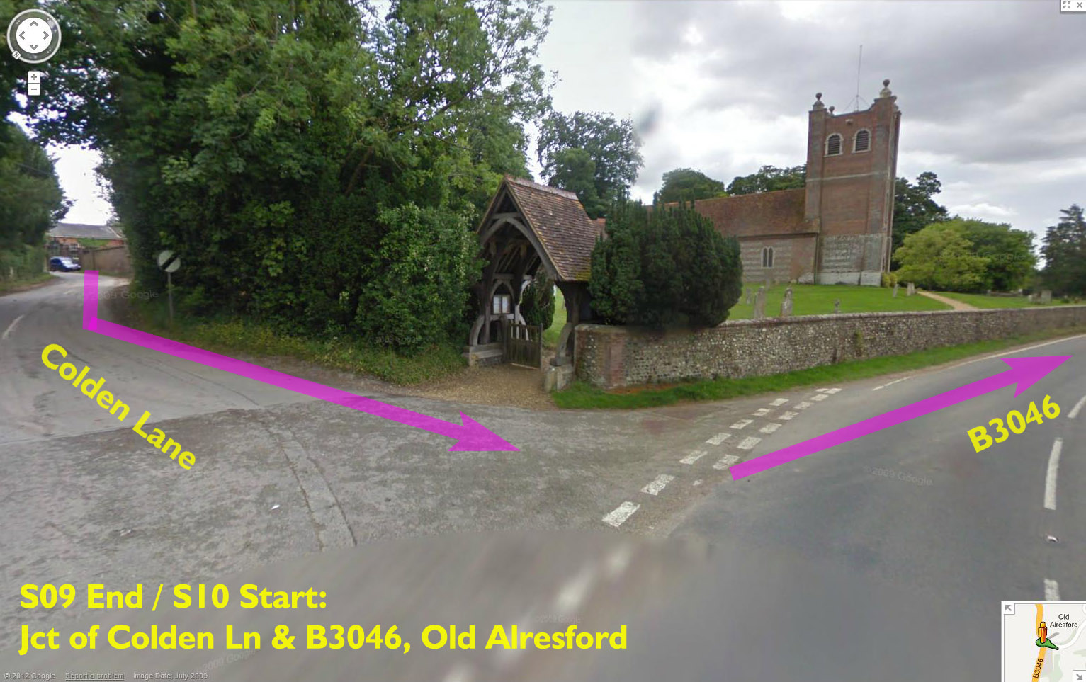
| FINISH Time: | 2:38 PM | ||||
| FINISH Location: | Church at junction of Colden Ln/B3046, Old Alresford | Satellite image of EXACT FINISH location | |||
| FINISH Post Code (approximately): | SO24 9DH | ||||
| FINISH OS co-ordinates: | SU588337 | Streemap of EXACT FINISH location | |||
| 1. Leave pub heading south and follow roads on GPX route file and/or route map. | |||||
| Garmin files (right-click to download): | s09.tcx | s09.gpx | |||
| Detailed map download: | Detailed map (zoomable Google map overlay) | ||||
| Designated runner(s): | Sue True, Andy Robinson, Paul Roberts, Paul Brittenden | ||||
| Stage 10: | Old Alresford to St Swithun's School (via country lanes) **route revised 06-Sept** | ||||
| Stage Mileage (mi): | 9.0 | Stage route map (overview) | |||
| Cumulative Mileage (mi): | 95.2 | ||||
| START Time: | 2:38 PM | ||||
| START Location: | Church at junction of Colden Ln/B3046, Old Alresford | Satellite image of EXACT START location | |||
| START Post Code (approximately): | SO24 9DH | ||||
| START OS co-ordinates: | SU588337 | Streemap of EXACT START location | |||
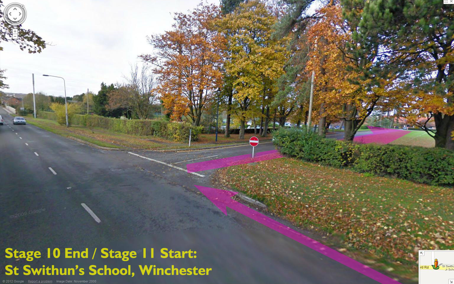
| FINISH Time: | 4:04 PM | ||||
| FINISH Location: | St Swithun's School, Alresford Rd (B3404), Winchester | Satellite image of EXACT FINISH location | |||
| FINISH Post Code (approximately): | SO21 1HA | ||||
| FINISH OS co-ordinates: | SU499294 | Streemap of EXACT FINISH location | |||
| 1. Leave church heading south on B3046. 2. After 0.2mi turn right into Abbostone Rd. 3. Follow GPX route file / detailed maps through Itchen Abbas to finish. |
|||||
| Garmin files (right-click to download): | s10b.tcx | s10b.gpx | |||
| Detailed map download: | Detailed map (zoomable Google map overlay) | ||||
| Designated runner(s): | Neil Barker, Lou Walker, Mark Lyman, Paul Brittenden | ||||
| Stage 11: | St Swithun's School to Winchester Sports Stadium | ||||
| Stage Mileage (mi): | 4.8 | Stage route map (overview) (to be added) | |||
| Cumulative Mileage (mi): | 100.0 | ||||
| START Time: | 4:45 PM | ||||
| START Location: | St Swithun's School, Alresford Rd (B3404), Winchester | Satellite image of EXACT START location | |||
| START Post Code (approximately): | SO21 1HA | ||||
| START OS co-ordinates: | SU499294 | Streemap of EXACT START location | |||
| FINISH Time: | 5:30 PM | ||||
| FINISH Location: | Winchester Sports Stadium, Bar End, Winchester | Satellite image of EXACT FINISH location | |||
| FINISH Post Code (approximately): | SO23 9SQ | ||||
| FINISH OS co-ordinates: | SU490287 | Streemap of EXACT FINISH location | |||
| 1. St Swithun's School. 2. Abbey Gardens (nr King Alfred). 3. Palmer's Field. 4. Winchester Sports Stadium. |
|||||
| Garmin route files: | GPX / CRS (to be added) | ||||
| Detailed map download: | (to be added) | ||||
| Designated runner(s): | Stage to be shared by
juniors. Details on the Stage Summary Page CLICK HERE |
||||
| Notes: | |||||
| 1. Post codes are approximate and only suitable for getting you "close" to the change-over. Refer to exact OS co-ordinates and descriptions for precise location. | |||||
| 2. Click on the links for route overview maps and for precise locations for hand-overs. | |||||
| 3. Please be at your change-over point between 45 and 60 minutes earlier than the time shown. | |||||
| 4. The runner holding the baton must be a WADAC member, wearing their WADAC vest/shirt. Other runners are very welcome to run alongside. | |||||
| 5. Please demonstrate restraint while running in the small hours, especially near private homes on the Thames Path. | |||||
| 6. Please be careful of traffic and courteous to other members of the public. | |||||
| 7. This is not a race and if you run too fast you'll be expected to stand still at the end of your stage to get back onto the correct timing! | |||||